Coverack
OS Grid ref:- SW 782 181
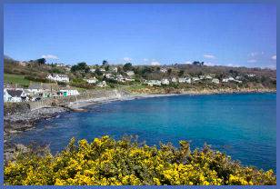 The pleasant and unspoilt fishing village of Coverack, situated on the south east corner of the beautiful Lizard Peninsula just to the north of the village of Cadgwith. Coverack occupies both sides of a spur of rock that juts into the Atlantic.
The village has a large sand and pebble, crescent shaped beach positioned in a sheltered bay that presents an ideal spot for windsurfing, sailing and diving. There is easy access to the beach via steps from the car park.
 The Manacles Rocks, which lie nearby, were once the site of many shipwrecks and are now a favourite diving destination. The Manacles bear a fearsome reputation,
The local hotel, named ' The Paris' derives its name from an American passenger liner of that name that ran aground on the Manacles reef in the mist on 21st May, 1899. Fortunately, no lives were lost. In the previous year, the steamship Mohegan was wrecked on the Manacles beyond Lowland Point and 106 people lost their lives a result.The Coverack lifeboat crew have rescued many from the Manacles, which claimed ships such as the Mohegan in 1898 with the loss of 106 lives, and HMS Brig Primrose, lost in 1809 with 120 officers and men, the only survivor being a drummer boy.
The Manacles Rocks, which lie nearby, were once the site of many shipwrecks and are now a favourite diving destination. The Manacles bear a fearsome reputation,
The local hotel, named ' The Paris' derives its name from an American passenger liner of that name that ran aground on the Manacles reef in the mist on 21st May, 1899. Fortunately, no lives were lost. In the previous year, the steamship Mohegan was wrecked on the Manacles beyond Lowland Point and 106 people lost their lives a result.The Coverack lifeboat crew have rescued many from the Manacles, which claimed ships such as the Mohegan in 1898 with the loss of 106 lives, and HMS Brig Primrose, lost in 1809 with 120 officers and men, the only survivor being a drummer boy.
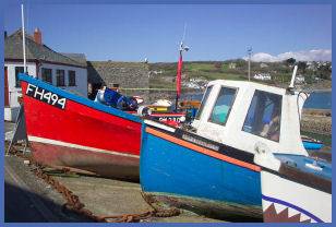 The small characterful harbour,
which dates to 1724, is constructed of local serpentine,
a dark green metamorphic rock veined with red. An old lifeboat house stands above the harbour which has not been used as such since 1977.
Dolphins may sometimes be sighted in the bay.
The small characterful harbour,
which dates to 1724, is constructed of local serpentine,
a dark green metamorphic rock veined with red. An old lifeboat house stands above the harbour which has not been used as such since 1977.
Dolphins may sometimes be sighted in the bay.
The small Victorian village church of St Peter dates from 1885 and has a serpentine pulpit, which was a gift from the old serpenting factory along the coast at Poltesco.
The village's name of Coverack derives from Porthcovrek and was recorded as early as 1262, it has been variously described as meaning witches cove, seaweed cove, wreckers cove or 'goveryk' meaning streamlet.
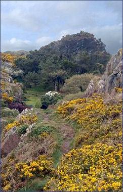
Poldowrian Garden,(pictured right) a beautiful wild garden, sits on the clifftop at Coverack and lies near to the South West Coast Path, it includes a prehistoric settlement discovered in 1965, dated by archaeologists at 5500 BC. A small Museum in a barn on the farm displays the finds, although some items were also deposited with the Royal Cornwall Museum in Truro. The Museum and Hut Circle are open to the public on request free of charge.
Coverack can be reached via Helston or Gweek over the Goonhilly Downs, which are famous for the Goonhilly Satellite Earth Station.
A walk from Coverack
Distance - 4 miles
*Commencing at the car park in Coverack, follow the road which leads towards the sea and turn left along the residential road that runs north parallel with the coast. Take the left fork shortly after reacing the end of the tarmac. Cross a stile and continue into the woods. Carry on along the passing rocky outcrops, until reaching a lane. Continue down it to reach Boscarnon Farm.
*Pass through a small wood to arrive at a lane that passes Trevalsoe Farm. Take the path leading to Trevean, turn left heading toward St. Keverne, turn right after 600 yards and continue in the direction of the sea. Offshore can be seen the Mannacles Rocks.
*Pass through a kissing gate and follow the descending path alongside a metal rail towards Lowland Point. After entering Lowland Point, Coverack will be visible in the distance. Return to the village via the coastal path.