Whitsand Bay
Os Grid ref:-
 Beautiful Whitsand Bay, runs from Rame Head in the east to Portwrinkle in the west. The bay is characterised by sheer, high cliffs, dramatic scenery and long stretches of sandy beaches.
Plymouth in Devon is situated only 7 miles away via the Torpoint Ferry service. The Cornish resort of Looe is around 6 miles west of Portwrinkle, along the coast, while Liskeard is located around 9 miles inland.
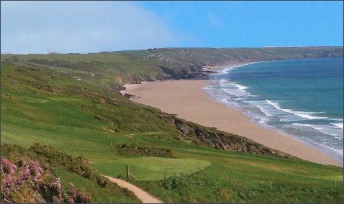
Whitsand Bay is arguably eastern Cornwall's best beach with a 3 mile stretch of perfect sand but access to the beach at Whitsand Bay is steep and there are limited facilities. Whitsand Bay can be used for surfing but there are rip currents. Car parking is available at Tregantle, Sharrow Point and Tregonhawke but access to the beach is difficult, via steep, uneven steps and paths, so not suitable for all.
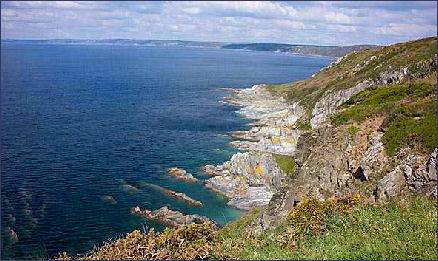
The bay is overlooked by Rame Head (pictured below left) , on top of which are the ruins of a fourteenth century chapel dedicated to St Michael. is a part of Mount Edgcumbe Country Park which is jointly owned and run by Cornwall Council and Plymouth City Council. Panoramic views are to be had from the summit, to the west along Whitesand Bay and east towards Plymouth Sound. 400 feet high cliffs slope into the sea while Dartmoor ponies graze around the head. The area is also inhabited by deer. There is a National Coastwatch look-out station at the head which is staffed by volunteers.
 Polhawn Cove has a rough beach, consisting of shingle and an area of open sand. West of Captain Blake's Point, long stretches of sand are interspersed with rocky headlands and small bays, many of which are inaccessible at high tide. The holiday settlements of Freathy and Tregonhawke are built on terraces on the cliff faces overlooking the bay.
The village of Portwrinkle has a small harbour and two beaches are accessible from it. The two sand and shingle beaches have numerous rock pools, A National Trust property at Sharrow Point preserves a small cave excavated by hand in 1874 by a hermit called Lugger, who inscribed verses on the ceiling to relieve his boredom. Lugger's Cave is fenced off to the public.
The South West Coast Path, which traverses the length of the bay, is the longest of England's national trails, running for six hundred miles from Minehead on the edge of the beautiful Exmoor National Park, to the shores of Poole Harbour in Dorset. The path is an excellent way to see Cornwall's superb coastal scenery, wildlife and unique heritage. In its Cornwall section the path traverses a variety of scenery, cliffs, secluded coves, and awe inspiring rock stacks.
At the western end of Whitsand Bay, Tregantle Fort stands 360 feet above sea level. It is hexagonal in shape and is surrounded by a ditch on three sides. The fort was completed in 1865 and included a barracks for 1,000 men. It was intended to be armed with 22 7-inch guns but only seven were ever fitted. It was used for musketry training during World War I and gas warfare training and accommodation for US troops in World War II. It is currently part of the Defence Estate and is regularly used as a live firing range with red flag warnings and the path down to the beach closed.
A Walk at Whitsand Bay
Distance- 6.5 miles (10.5km)
Duration- Around 3 hours
(1) Commencing at Freathy parking area, (grid ref: SX395523) , cross the road and join the South West Coast Path heading in a westerly direction.
(2)On nearing Tregantle Fort you will arrive at a junction, follow the path straight ahead if the flags are not flying, keeping right until reaching the large gates, from here follow signs for the permanent route. If the red flags are flying at Tregantle Fort, join the road on a sharp bend signposted to Portwrinkle. If the red flags are not flying at the entrance to the range, exit onto the road and follow the signs for the permanent route which will take you alongside the B3247 towards Crafthole to a small lane junction
(3)Turn right off the road heading north down the hill. On arriving at the junction at Lower Blerrick turn left towards Kerslake. If there are no flags flying there is an option of a shorter walk. Instead of turning right towards Blerrick Farm, continue along the road and join the permanent route for the South West Coast Path. Follow the footpath until it meets up at the MoD gate to rejoin the return route.
(4)Passing the ponds at Kerslake, bear right up the lane towards Trethill House. At the road junction in between several barns and a house turn right and follow this lane down towards the A374. Just before reaching the main road (A374) a footpath is signposted on your left that leads you up a valley towards Crafthole. Follow this path along the edge of several fields, across a wooden footbridge, through woodland and up past Crafthole reservoir.
(5)As the footpath nears the top it joins the main road (B3247). Turn left towards the roundabout and then right towards Portwrinkle passing the Finnygook Inn. Continue along the road following signs to Portwrinkle on your left. After a short walk down the hill take the footpath through the golf course until you rejoin the South West Coast Path. When you reach the South West Coast Path past Skinners Ball turn left (heading east) back towards Tregantle Fort.
(6) C ontinue through the golf course and enter National Trust land at Trethill. Continue along the path until you reach the gate entering the MoD land. If there are no flags flying, follow the waymarked path through the range. Going through the gate at the end of the range, follow the waymarkers through the field above Kerslake Cliff and rejoin the return route. If flags are flying, follow the footpath round Tregantle Fort and take the footpath that leads out towards the road. Continue on the footpath that runs alongside the road and retrace your steps back to the car park.