OS Grid ref:- SX2468
 The village of St. Cleer, known in the Cornish language as Ryskarasek, is siuated on the south eastern edge of Bodmin Moor and lies around two miles (3 km) to the north of the historic town of Liskeard.
The village's name is thought to derive from St. Clarus, a ninth century Benedictine monk and English missionary who was martyred near the River Epte in Normandy in 894. Clarus was born near Vienne, Dauphine', France. He became a monk at St. Ferreol Abbey and later was spiritual director of St. Blandina Convent, where his mother and sister were nuns. In time he became Abbot of St. Marcellus monastery at Vienne and lived there until his death.
The village of St.Cleer has two pubs, the Stag Inn on Fore Street, which has a warm and friendly atmosphere, together with good homemade food and the Market Inn on Well Street, a friendly traditional moorland village pub, built in 1860 as lodgings for miners where food is also available. There is also a Post Office & General Store/Newsagents and Farm Shop for local food.
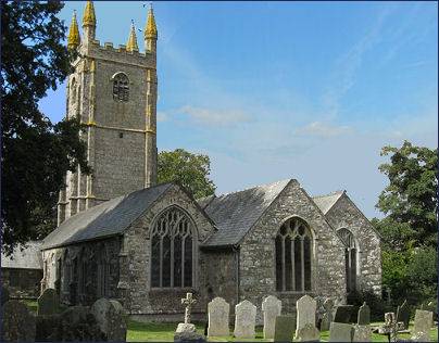
The handsome village church, (pictured below) with its commanding granite tower, was first built of wood around 800 A.D, but was rebuilt towards the end of the thirteenth century and the church tower, which measures 97 feet in height, was constructed more recently in the fifteenth century. The font is of early English character with some Norman features. There is a south porch, a chancel door and an early Norman doorway on the north side, ornamented on the outside with a zig-zag moulding.
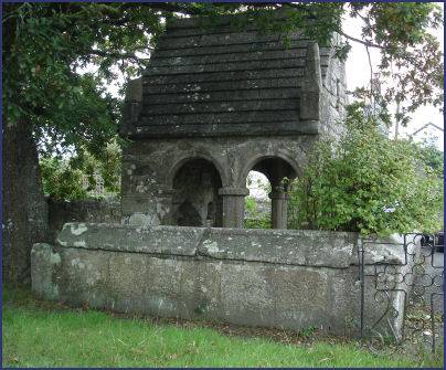
 The holy well in the village (pictured left), which is dedicated to St. Clarus,
has been covered by a granite gothic style open chapel.
The well was once seen as a place of healing magic a destination for medieval pilgrims who came here to cure skin diseases.
The holy well in the village (pictured left), which is dedicated to St. Clarus,
has been covered by a granite gothic style open chapel.
The well was once seen as a place of healing magic a destination for medieval pilgrims who came here to cure skin diseases.
The water from the well flows into a pool which is supposed to have been a bowsening pool, where the insane were ducked in order to effect a cure. A cross which measures around seven feet high stands next to the well. The chapel was destroyed by religious fanatics during the Civil War, after which it lay in ruins for nearly 200 years before being restored.
The village has two pubs, a farm shop a post office, newsagents and general store and offers a range of accommodation.
Around a mile north west of St. Cleer lie the King Doniert Stones, which are two granite slabs with Latin inscriptions and intricate patterns. One reads "Doniert Rogavit Pro Anima" (Doniert prayed for his soul). They are the remains of two crosses associated with the Dark Age Celtic King Doniert or Durngarth, who drowned in the river Fowey about 875 AD and was the last independent King of Cornwall.
The imposing prehistoric megalith of Trethevy Quoit which lies around a mile to the north of St. Cleer, is one of the best known of Cornwall's prehistoric monuments and is remarkably well preserved. The area features rugged granite outcrops, Siblyback Lake, a reservoir and watersports centre and the attractive Golitha Falls, a Nature Reserve, lie nearby.