Camelford
OS Grid ref:- SX101831
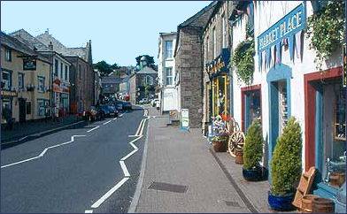 The small market town of Camelford, known in the ancient Cornish language as Ryskammel, lies on the banks of the River Camel, it is situated to the north west of Launceston on the edge of Bodmin Moor and is around six miles from the spectacular Cornish coast.
The ancient town makes an excellent base for touring the surrounding area, as it is centrally located for either the beach and the seaside or equally the moors and inner, North Cornwall with its superb countryside. Lying at over 700 feet above sea level Camelford is one of the highest towns in England. Granted its charter by Richard, Earl of Cornwall, the brother of King Henry III in 1259, the town grew to become an important river crossing on the route from Launceston, Cornwalls former capital, to the market town of Wadebridge.
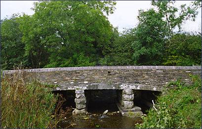
Camelford has been claimed to be the site of King Arthur's legendary fortress of Camelot. Slaughterbridge (pictured right) is said by some sources to be the location of Arthur's last battle against his arch rival Modred in 542AD. The Arthurian Centre has a 'Land of Arthur' exhibition and features brass rubbing, the 'Grail Trail' , video and shop.
 The name Camelford derives from the old Cornish for a curved river 'Cam pol'. The town offers a wide range of shops, accommodation, amenities and an excellent riverside walk. It boasts 3 golf courses, a sports centre, tennis courts and indoor heated swimming pool.
Camelford is the home of the North Cornwall Museum and Gallery which contains paintings and many objects of local historical interest. The handsome Bridge House dates from the seventeenth century, a bridge has occupied the location since before 1521. Just south of the town is a footpath that leads onto Bodmin Moor.
Camelford Town Hall was built in 1806 by the Duke of Bedford and sports a weather vane in the shape of a golden camel. The building was originally the market hall. The parish church of Camelford is at Lanteglos by Camelford though although there is also a Church of St Thomas of Canterbury which was opened in 1938, in the town.
Enfield Park has recently undergone extensive restoration and offers excellent walks along the River Camel down to Slaughterbridge.
Nearby Rough Tor, now owned by the National Trust, has over a hundred Bronze Age round houses with many burial cairns. . The summit of Rough Tor rises to 1,313 feet (400m) above sea level, meaning it is the second highest point in Cornwall.
Slaughterbridge- the Battle of Camlann
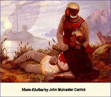 The medieval chronicler, Geoffrey of Monmouth, writes in his famous 'History of the Kings of Britain' informing us that the legendary King Arthur's last battle, the Battle of Cammlann, known in Welsh as Cad Camlan or Brwydr Camlan, took place at a site beside a river in Cornwall. Legend relates the battle was fought against against his nephew and illegitimate son, his mortal foe, Mordred, son of his sister Morgan le Fey.
No river of such a name exists in modern day Cornwall, but the reference is understood by many to refer to the River Camel. Local legends abound that the Dark Age battle was fought in a water meadow beside the Slaughterbridge. The legend relates that Arthur was in Europe fighting (according to earlier sources) Emperor Lucius or (according to later sources), Lancelot. On Arthur's return to Britain, a series of battles ensued that climaxed with the Battle of Camlann. Both Arthur and Mordred were mortally wounded in this battle, but Arthur's forces triumphed.
On the stream bed at Slaughterbridge lies a sixth century inscribed stone, said to mark the spot were Arthur fell after meeting Morded in battle.
Discrepancy exists as to the actual date of the battle. The Annals of Wales claim it to have been fought in 539 A.D. , whilst the Annals of Ulster record it by another name, the Battle of Manann, and date its occurence as 582 A.D.
Adomnal, a monk who wrote in the seventh century, describes Arthur's death in the battle. Later accounts of the battle occur in Geoffrey of Monmouth's 'History of the Kings of Britain' and the thirteenth century Welsh tale 'The Dream of Rhonabwy'.
Places to visit in Camelford
The Arthurian Centre King Arthur exhibition and battle trail.
* North Cornwall Museum and Art Gallery,The Clease, privately owned. Represents country trades and recreation of life in country villages more than a century ago. Displays on different facets of industrial and agricultural history. The gallery has exhibitions of arts and crafts.
* Camelford Museum of Historic Cycling, Britain's foremost collection of cycling memorabilia housed in an old Victorian railway station. Over 300 bicycles on display, exhibits include bicycles from 1818 to the present day along with posters, medals and fobs.