Navax Point
OS grid ref:- SW 591 434
 Beautiful Navax Point is situated near the Cornish coastal village of Gwithian and is just beyond Godrevy Lighthouse, the point makes a superb setting for a cliff top walk and is owned and maintained by the National Trust.
The name derives from the Cornish words Penn Kynyavos, meaning head of the autumn dwelling.
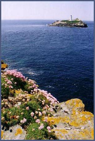
Godrevy Island, which is seen off Navax Point, is partly covered with grass, The island sland is home to gulls, oystercatchers and pipits. Like the mainland, in spring it is bright with wildflowers, including primroses and thrift.
Godrevy Lighthouse was constructed between 1858 and 1859 by Trinity House, at a cost of over £7000. It stands on the largest rock of the Stones reef, which had always been a hazard to shipping and a lighthouse had been considered many times prior to 1858 but nothing came of plans until the SS Nile was wrecked on 11 November 1854, with the loss of all on board.
The lighthouse is a white octagonal tower, measuring 86 feet (26 metres) in height and is constructed of rubble, stone and mortar. The structure is said to have inspired Virginia Woolf to write the novel 'To the Lighthouse', although she locates the lighthouse in the Hebrides.
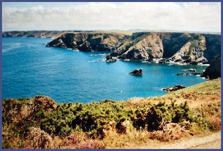
South of Navax Point is an area of heath known as the Knavocks, which is managed by The National Trust. The grassland and gorse scrub is crossed by several footpaths and is home to many species of butterflies and birds, notably nesting stonechats. The Knavocks, like other coastal heathlands in Cornwall, is managed by regularly cutting back the gorse and by grazing.
The area of high ground provides some superb views of the Cornish coastline. On a clear day, there are stunning views across the bay and up along the North Cornwall coast. To the west, St Ives and the beaches that arc around to Godrevy Point and Godrevy Island and Lighthouse. To the north east, the coastline at Chapel Porth Beach and St Agnes Beacon. To the east is the distinctive Basset Monument on Carn Brea.
The Knavocks is home to wild ponies, which were introduced by the National Trust. In July and August the area around Navax Point is awash with pink heather and brilliant yellow gorse. Wildflowers abound in the grass and Atlantic seals can sometimes be seen, although elusive and preferring the rougher seas. All kinds of sea birds can be sighted. In summer porpoises have been seen from the point.
The rocky outcrops and cliffs are magnificent. Just offshore is Godrevy Island, which was the scene of a famous shipwreck in 1649. In the aftermath of the execution of King Charles I, followers attempted to send his lace trimmed garments and other possessions abroad for safe keeping as relics of the 'Martyr King'. The ship was wrecked and only a few of the clothes were washed ashore.
A walk from Navax Point to Basset Cove
Distance -3.5 miles
Duration - around 2 hours
*Commencing at the car park at Godrevy, continue to the point overlooking the lighthouse. Walk Round the point and continue along the footpath towards Navax Point.
*Continue along this path which overlooks the small coves of Castle Giver Cove and Fishing Cove. The path then ascends to the top of Hell's Mouth at 88m (almost 290 feet) the highest point in the walk.Care should be exercised near the cliffs.
*After passing Hudder Cove and Deadman's Cove. The path joins the road at Derrick Cove where the path and the road run almost adjacent over Reskajeage Downs.
Retrace your steps to return to the car park at Godrevy