Perranzabuloe
OS Grid ref:- SW 770 520
 The hamlet of Perranzabuloe lies on the west coast of Cornwall, just over a mile (2 km) south of Perranporth and seven miles (11 km) to the south-southwest of the resort of Newquay.
Known in Cornish as Pyran yn Treth, the name derives from the medieval Latin Perranus in Sabulo which means Piran in the sand, in reference to Saint Piran, patron saint of Cornwall, whose flag of a white cross on a black background can be seen throughout Cornwall. St. Piran founded an oratory church near the coast north of Perranporth in the seventh century.
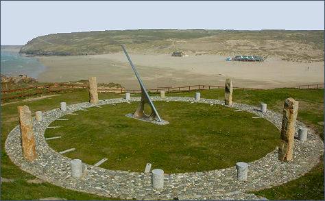
A huge cliff top sundial occupies the site of the former Droskyn Mine overlooking Perranporth Beach. Constructed in the form of a circle of standing stones; each marked with an hour. A stainless steel gnomon casts shadows onto the stone clockface and seating has been incorporated into the design. The stones are aligned so they show the Cornish Time rather than Greenwich Mean Time.
The Perranzabuloe Museum features exhibits which provide an interesting insight into the life and history of Perranzabuloe parish - from its earliest beginnings; the arrival of St Piran; the growth of fishing, farming and mining; the development and closure of the railway; to the tourist resort it has now become.
The village church was dedicated to St Piran in July 1805. Much of the building was constructed using materials from St Piran's Old Church.
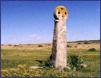
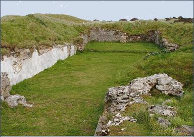 St Piran's Oratory stands in the sand dunes known as Penhale Sands. Legend states that St Piran landed on Perran beach from his native Ireland and built the oratory in the Irish style. The first oratory was probably built of wattle and daub and replaced in stone at a later date. The oratory was very simple in plan and was barely 30 feet (9.1 metres) long, the encroachment of the sand led to the abandonment of the oratory in the tenth century and it was replaced by another church, now known as St Piran's Old Church, completed by the twelfth century, it was enlarged in 1462, which was also gradually engullfed in the enroaching sand. St Piran's Cross which is believed to be the earliest recorded stone cross in Cornwall, stands in the dunes between the oratory site and the graveyard of the old church. It is dedicated to tinners and miners and stands at 8 feet (2.4 m) high.
The oratory site was excavated in 1910 but its remains are now buried in the sand again. The site of St Piran's Old Church and the tenth century cross next to it were excavated in 1919. A fund for re-excavation of the site began in early 2014. Three carved stone 'Celtic' heads, of a man, woman, and cat are in the care of the Royal Cornwall Museum.
In Saxon times a monastery, known as Lanpiran or Lamberran, stood near the oratory site but it was disendowed circa 1085 by Robert, Count of Mortain, the half-brother of William the Conqueror. The relics of St Piran were preserved in St Prian Old Church which became a centre of pilgrimage. The relics are recorded in an inventory made in 1281 and were still venerated in the reign of Queen Mary I.
A walk to St. Pirans Oratory
Distance - around 4 miles
Duration - about 2 hours
 *Parking on the minor road that branches from the B road about a mile east of Perranporth, take the path that commences opposite the lane from Rose.
Pass through the gate and continue along the path which is marked with white stones.
*Parking on the minor road that branches from the B road about a mile east of Perranporth, take the path that commences opposite the lane from Rose.
Pass through the gate and continue along the path which is marked with white stones.
*Bear to the right following the acorn posts of the Coastal Path heading towards the stone cross which is visible on the skyline. The celtic cross dates to about 900 A.D and marks the site of the Norman church which was built there to replace St. Pirans oratory.
*Continue downhill heading towards the sea crossing the sand dunes until reaching the mound which covers St. Pirans Oratory, which is topped with a rough granite block marked 'St. Piran'.
Continue towards the sea, with extensive views on all sides. Follow the left path, cross a road and carry on along the cliffs, Perranporth is soon within view, the way slopes gently down to the beach.
*Cross the sands and keep left to meet the river, follow the track beside the river out onto the road. Turn left and left again at a waymarker, climbing steep steps. Remain to the left of the clubhouse and cross the road to a stile. Continiue diagonally up a field toward a goal post. Another stile leads over the road to a path which leads to a lane. A right turn will return you to your car.