West Pentire
OS Grid ref:- SW 775 605
 The village of West Pentire on the north coast of Cornwall is situated 2.5 miles (4.0 km) west of the resort town of Newquay.
The village derives its name from the Cornish word Pentir meaning promontory.
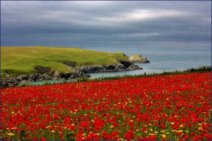
To the west lie the West Pentire Fields, owned by the National Trust and covering 16 hectares. The coastline just to the south of Newquay is delightfully varied with superb, colourful displays of arable flora in summer months.
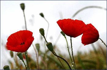
At West Pentire, whole fields with vivid scarlet poppies and other rare meadow plants flourish. There is an abundance of sandy grassland, rich in wild flowers such as cowslip and pyramidal orchid.
Other plants include venus's-looking-glass, shepherd's needle, small -flowered Catchfly and night-flowering catchfly, western ramping-fumitory and the weasel's-snout. At other times the pyramidal orchid and the carline thistle may be seen.
 Further towards the coast, the clifftops are carpeted in rock sea lavender and sea campion , while in the in the early summer months they are covered with a mist of sea pinks or thrift. and autumn squill may be sighted while the sand dunes are home to sea holly, henbane and hound's-tongue.
The West Pentire fields have been designated as an Important Plant Area, by the organisation Plantlife, due to its arable flora, particularly poppies and corn marigolds.
The South West Coast Path traverses Pentire Point. The lower path at Pentire Point passes a collapsed sea cave, one of many on the North Cornish coastline. The cave was carved into the rock by the erosive action of the waves, which then washed around inside it, causing the roof to fall in. The beach at Porth Joke, known locally as 'Polly Joke', derives from the Cornish 'Porth Lojowek', meaning 'cove rich in plants'. Extensive views are to be had from the Point. To the south and west the expanse of Padstow Bay and the mouth of the River Camel are visible. The headland furthest away is Polzeath, the daymark at Stepper Point marks the entrance to the mouth of the estuary.
A walk from West Pentire
Distance :- 6 miles
Duration :- 2 hours
(1) Commencing at the car park at West Pentire (OS grid ref:- SW775605) take the northern path towards the coast, during the summer months, the wild flower fields will be on your left.
(2) On arriving at ajunction take the path on your left, then the next right continuing along the edge of a field. At the end of this field take the left-hand path, then the right one, on the edge of the coast, following it around to the left, away from West Pentire.
(3) Continue to follow the coastal path, pass the Iron Age fort on your right then follow the path, which loops around the sand dunes of Holywell Beach.
(5) The path then leads inland off the beach. Follow it straight across the junction, then downhill to another four-way junction, taking the left-hand path. Carry straight on, turning left at the track, then further on keeping right past the disused quarry.
(6) Follow the fork forward then take the next small path on the left. Follow the track uphill past another disused quarry on the right and along the fieldsto return to the car park.