Morvah
OS Grid ref:- SW402353
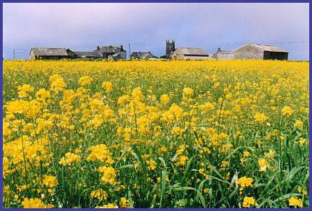 The small fishing village of Morvah, derived from the Cornish Morveth meaning 'a place by the sea', lies on the north coast road of the extreme south-western peninsula of Cornwall.
Evidence of a settlement at Morvah in the early Middle Ages is presented in the form of an inscribed stone known as the Mên Scryfa, it is a memorial to 'Rialobranus son of Cunovalus', the stone is located in a field on the moor about three kilometers from the village. Morvah , which was a busy mining area in the nineteenth century, consists of several granite houses, an art gallery, a dairy farm, a Wesleyan Chapel and a church which dates to the fifteenth century.
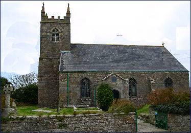
The village church was dedicated in 1409 to St Morwetha, and was constructed by the Knights of St John. It was later dedicated to St Bridget of Sweden, who had formed the order of Bridgentines in 1373. Some of the ornamentation within the church is of Swedish manufacture.
The Neolithic dolmen of Chun Quoit dating from circa 3500 BC, stands in Morvah parish, as does and the nearby Iron Age hillfort (c. 300 BC) of Chûn Castle, as well as the Late Iron Age settlement of four distinctively local courtyard houses at Croftoe.Just off the road that links Morvah to the nearby village of Madron, stands Men-an-Tol, a Bronze Age circular holed stone, flanked by two upright stones which was once believed to have curative powers for those who crawl through.
In the course of quarrying for building materials at Morvah in 1884 a hoard of gold ornaments dating from the late Bronze Age were discovered at Carne Farm, which lies about half a mile to the north of Chun Castle and quoit. The hoard consisted of six large Irish gold bracelets, three of which displayed distinctive trumpet-like ends. The bracelets are now on display at the British Museum.
 Up on the cliffs at Tregaminion Farm is a Holy Well which dates to the Bronze Age and stands near the site of an early Christian chapel dating to the Dark Ages. Water from the well was used by the villagers until the 1960's when mains water was installed in the village.
St Bridget's Church
Morvah's village church, dedicated to St Bridget, dates from the late medieval period. The building is said to have superseded a small chapel situated on the cliffs near Madron. The tower is the only remaining medieval part of the church. The rest was rebuilt in 1828.
The church was dedicated to St Morwetha in 1409, and was built by Knights of St John as a daughter to the church at Madron. Soon after, however, the church was dedicated to St Bridget of Sweden, who had formed the Order of Bridgentines in 1373. This church is said to have superseded a small chapel on the cliffs near Madron.
Towns and Villages of Cornwall