Pendeen
OS Grid ref:- SW384344
 The small Cornish village of Pendeen lies at at the northwestern tip of Penwith district and is situated three miles (4.8 km) east of St. Just. Pendeen was once a haven for smugglers. Its name (Cornish: Penndin) means 'headland of a fort'.
The village has three beaches and a very good range of shops, art galleries and pubs.
Pendeen is famous for the Geevor Tin Mine, the largest mining history site in the UK, which was visited by the Queen and The Duke of Edinburgh in 1957. The mine incorporated part of the old Levant mine, with one gallery 2,000 feet below the sea-bed. Pendeen has a history of mining which dates back over 3000 years. The mines there were worked in Roman times, the Geevor Tin Mine closed in 1990. The nearby Crowns engine houses are dramatically perched on the coast at nearby Botallack. The Count House, Botallack, now owned by the National Trust, contains information about the Crowns and other industrial heritage sites in the area.
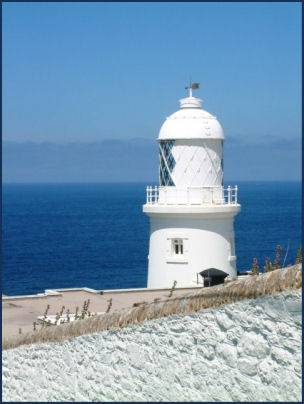
Pendeen Lighthouse (pictured left) stands on the promontory of Pendeen Watch, which can accessed from a lane opposite the village car park. The lighthouse and was built in 1900. The wreck of the ship 'The Liberty', can be seen on Liberty Rock below the lighthouse, much of the ship has now rotted away but sections of the wreck are still visible at low tide. The veiws from Pendeen Watch are excellent and it presents a good location to spot seals, kestrels and buzzards
Pendeen House was the birthplace of William Borlase, the antiquarian and writer of the history of Cornwall, whilst Pendeen Manor Farm dates from the sixteenth century.
Pendeen is overlooked by a hill which is known to locals as 'The Carn'. It was the site of a quarry which was once used to mine granite. Pendeen Fogou, otherwise known as Pendeen Vau, is situated in the farmyard at Pendeen Manor farm, close to Pendeen Manor House, which was once the home of the early archaeologist William Borlase, who was born there in 1693 and is considered to be the 'father of Cornish archaeology.
Image copyright Mari Buckley
A walk to Botallack from Pendeen Lighthouse
Distance- 2 miles
Duration- Around 80 minutes
*Parking at small car park by Pendeen Lighthouse, proceed inland, turn right after passing a row of houses and folow the coastal path signs.
*Walk down into a valley, crossing a stream, remain on the right hand side of the stream and follow the indistinct path for around five minutes, leading out to an area of flat grassland overlooking the the Enys - an inshore island. Return to, and cross the stream and continue up the other side of the valley.
*Proceed down to Trewellard Bottoms, passing Geevor Mine and proceed along the waymarked footpath Levant Mine. Passing the mine buildings, go through the car park and take the track leading in a southwesterly direction, continue along this track until arriving at Botallack.
*To return either retrace your footsteps or follow the waymarked Tinner's Way to return to Pendeen Lighthouse.