OS grid ref:- SW409257
 The pleasant village of St Buryan is known in Cornish as Eglosborrie and acquires its name from the sixth century Irish Christian missionary Saint Buriana. local legend describes how, whilst ministering to the local inhabitants from the oratory that stood on the site of the current church, Saint Buriana was abducted by the local king, Geraint of Dumnonia. Saint Piran, patron saint of Cornwall and also a fellow missionary, negotiated for her release.
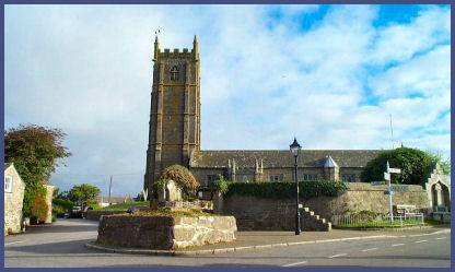
The church of St. Buryan occupies a site that has been a place of worship since the fifth century. The Saxon King Athelstan, grandson of Alfred the Great, founded a church on the site in around 930, in thanksgiving for his conquest of Cornwall. A revolt against Anglo-Saxon rule in 931 AD by the Cornish Celts, who were supported by the Danes) led to a battle southeast of the village at Boleigh where a farm and hamlet now stands. The Saxon king Athelstan crushed the Celtic resistance.
A local story tells of ancient armour being ploughed up in the nearby fields at Gul Reeve (a corruption of the Cornish Gwel Ruth, meaning red field). According to tradition, King Athelstan rested overnight in the cell attached to the small Oratory of St.Buryan .before he sailed to conquer the Isles of Scilly. The next morning the King is said to have made communion and vowed that if he were successful he would found and endow a church. Athelstan's church was built on the site of the ancient oratory of Saint Buriana.
 The church, a Grade I Listed Building, was rebuilt in the fourteenth century while the present tower dates to 1501. The interior boasts a beautiful, intricately carved rood screen while the granite font probably dates to the thirteenth or early fourteenth century. The Boleit tomb, which lies in the floor of the tower, has a Norman-French inscription and dates to the thirteenth century, it was uncovered by a sexton in 1665.
St Buryan is mentioned in the Domesday Book, where it is referred to as being in the ownership of Robert, Count of Mortain. Celtic crosses abound throughout the parish, located at roadsides and road junctions, which are thought to be sanctuary markers, King Athelstan granted a charter of extended sanctuary to St Buryan.
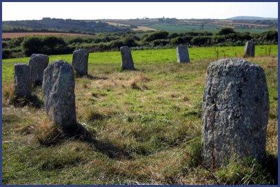
The area is rich in prehistoric remains, the enigmatic Boscawen Un Stone Circle lies around 1.5 km to the north of the village. The stone circle is mentioned in a Medieval Welsh manuscript as one of the three main Gorsedds or meeting places of the ancient Britons, the modern Cornish Gorsedd first met here in 1928 and it is still used by modern pagan groups. The Tregiffian Burial Chamber and the Merry Maidens Stone Circle (pictured right) are located to the south, the stone circle dates to the Bronze Age, local legend states that the stones are the forms of a group of nineteen maidens who danced on the Sabbath and were turned to stone for their transgressions!
Image copyright Richard Knights
A walk from St. Buryan to Porthcurno
Distanve- around 8 miles
*Commencing at St. Buryan, follow the track located at the left of the post office, passing a farm, join the road at the path junction (Grid ref. SW 419242)and turn right. Turn left at the path which leads down a wooded valley to the sea.
*Upon arriving at the coastal path turn right folowing the path which climbs Trevedran Cliff. Continue to follow the path past the fishing village of Penberth and along the cliffs to Treryn Dinas.
*Proceed along the path to reach Porthcurno. Turn inland via the car park to arrive at a road, follow the road through Trethewey to reach the B3135. Pass straight across onto a footpath, athe point where the path rises to meet a lane turn right and proceed to a T-junction at Bottoms.
*Go right to reach another junction, then take a further right up to Crean, follow the narrow lane to join the main road. Take a left turn onto the road which leads back into St. Buryan.